檔案:Zhujiangrivermap.png
覽幅:寛八〇〇高五四二微格。 他晰:寛三二〇高二一七微格|寛六四〇高四三三微格|寛九八八高六六九微格。
全幅 (微格九八八矩六六九,度:三〇八 KB,多用網際網路副檔名之型:image/png)
概
| 述 |
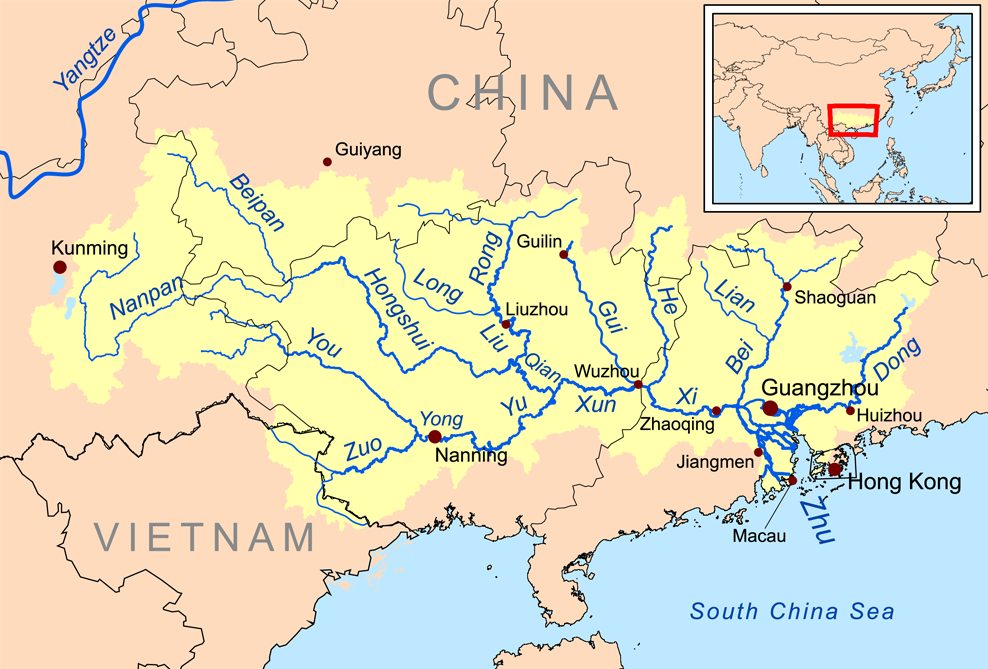
English: Map of the tributaries of the Pearl River, and the Pearl River Basin (watershed/drainage basin) in yellow.
|
| 期 | |
| 碼 | 己作 |
| 作者 | Kmusser |
| 其他版本 | 愛沙尼亞文 |
權
我,本作品的著作權持有者,決定用以下授權條款發佈本作品:
此檔案採用創用CC 姓名標示-相同方式分享 3.0 未在地化版本授權條款。
- 子可:
- 享 – 複製、發佈和傳播本作品
- 重改 – 創作演繹作品
- 惟需遵照下列條件:
- 享 – 您必須指名出正確的製作者,和提供授權條款的連結,以及表示是否有對內容上做出變更。您可以用任何合理的方式來行動,但不得以任何方式表明授權條款是對您許可或是由您所使用。
- 共享 – 如果您利用本素材進行再混合、轉換或創作,您必須基於如同原先的相同或兼容的條款,來分布您的貢獻成品。
檔誌
揀日尋檔。
| 日時 | 縮 | 度 | 用戶 | 註 | |
|---|---|---|---|---|---|
| 今 | 二〇一五年一二月二一日 (一) 一三時五九分 | | 九八八矩六六九(三〇八 KB) | Ras67 | cropped |
| 二〇〇八年一一月一九日 (三) 二〇時〇九分 |  | 一〇〇〇矩六八一(三四六 KB) | Kmusser | {{Information |Description=This is a map of the Pearl River drainage basin. |Source=Own work using http://www.maproom.psu.edu/dcw/ Digital Chart of the World and [[http://edc.usgs.gov/products/elevation/gtopo30/gtopo30.html |
檔所繫者
下頁連本檔:
總文之用
下他共筆連本檔:
- af.wikipedia.org上之用
- ar.wikipedia.org上之用
- arz.wikipedia.org上之用
- ast.wikipedia.org上之用
- azb.wikipedia.org上之用
- az.wikipedia.org上之用
- ba.wikipedia.org上之用
- be.wikipedia.org上之用
- bg.wikipedia.org上之用
- bh.wikipedia.org上之用
- bn.wikipedia.org上之用
- ceb.wikipedia.org上之用
- cs.wikipedia.org上之用
- da.wikipedia.org上之用
- de.wikipedia.org上之用
- en.wikipedia.org上之用
檢視此檔案的更多全域使用狀況。