檔案:LA County Incorporated Areas Los Angeles highlighted.svg

此 SVG 檔案的 PNG 預覽的大小:寛七三〇高五九九微格。 他晰:寛二九二高二四〇微格|寛五八五高四八〇微格|寛九三五高七六八微格|寛一二四七高一〇二四微格|寛二四九四高二〇四八微格|寛九五〇高七八〇微格。
全幅 (SVG檔,貌有像素九五〇矩七八〇,幅二六一 KB)
概
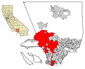
| 述 | This map shows the incorporated areas in Los Angeles County, California. Los Angeles is highlighted in red. I created it in Inkscape using data from the Los Angeles County Website (Los Angeles County Incorporated Area and District Map (PDF). |
| 期 | |
| 碼 | My own work, based on public domain information. Though I strove to be as accurate in the detail as possible, the information shown is not guaranteed to be completely accurate. |
| 作者 | Ixnayonthetimmay |
| 准 (重用此檔案) |
Public Domain |
| 其他版本 | See Category:Maps of Los Angeles County, California for other versions of this image. |
權
| 我,此作品的版權所有人,釋出此作品至公共領域。此授權條款在全世界均適用。 這可能在某些國家不合法,如果是的話: 我授予任何人有權利使用此作品於任何用途,除受法律約束外,不受任何限制。 |
檔誌
揀日尋檔。
| 日時 | 縮 | 度 | 用戶 | 註 | |
|---|---|---|---|---|---|
| 今 | 二〇〇七年六月二六日 (二) 〇七時一九分 | | 九五〇矩七八〇(二六一 KB) | Ixnayonthetimmay | == Summary == {{Information |Description=This map shows the incorporated areas in Los Angeles County, California. Los Angeles is highlighted in |
檔所繫者
下頁連本檔:
總文之用
下他共筆連本檔:
- af.wikipedia.org上之用
- als.wikipedia.org上之用
- ang.wikipedia.org上之用
- ar.wikipedia.org上之用
- arz.wikipedia.org上之用
- ast.wikipedia.org上之用
- azb.wikipedia.org上之用
- bg.wikipedia.org上之用
- bh.wikipedia.org上之用
- bn.wikipedia.org上之用
- ca.wikipedia.org上之用
- chy.wikipedia.org上之用
- de.wikipedia.org上之用
- diq.wikipedia.org上之用
- dty.wikipedia.org上之用
- el.wikipedia.org上之用
- en.wikipedia.org上之用
- Los Angeles
- Los Angeles Police Department
- Harbor Gateway, Los Angeles
- Municipal annexation in the United States
- Category:Neighborhoods in Los Angeles
- National Register of Historic Places listings in Los Angeles
- Killing of Ezell Ford
- Wikipedia talk:WikiProject China/Archive 26
- Talk:New York (state)/Archive 7
- User:Hparham865
- User:DraconicDark/Black Lives Matter Portal
- User:Nate.beisheim/sandbox10
- en.wikinews.org上之用
- es.wikipedia.org上之用
- eu.wikipedia.org上之用
- ext.wikipedia.org上之用
- fa.wikipedia.org上之用
- fi.wikipedia.org上之用
- fo.wikipedia.org上之用
- fr.wikipedia.org上之用
- Los Angeles
- Projet:Charte graphique/Domaine géographique
- Los Angeles Police Department
- Modèle:Infobox Ville des États-Unis
- Modèle:Infobox Ville des États-Unis/Documentation
- Gangster Squad (LAPD)
- Community Resources Against Street Hoodlums
- Division métropolitaine du Los Angeles Police Department
- Modèle:Infobox Ville des États-Unis/Bac à sable
- fr.wikinews.org上之用
檢視此檔案的更多全域使用狀況。