檔案:India Sikkim locator map.svg

全幅 (SVG檔,貌有像素一五七四矩一七三八,幅八三六 KB)
| 標題 |
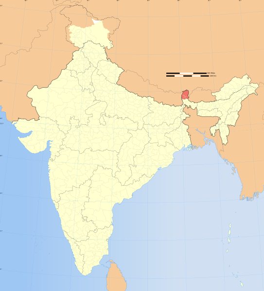
Sikkim locator map |
|||||||||
| 描寫 |
Locator map of the state of Sikkim, India with district boundaries. |
|||||||||
| 地圖圖例 |
 |
|||||||||
| 期 | ||||||||||
| 碼 |
己作 |
|||||||||
| 創作作者 |
|
|||||||||
| 准 (重用此檔案) |
我,本作品的著作權持有者,決定用以下授權條款發佈本作品: 此檔案採用創用CC 姓名標示-相同方式分享 3.0 未在地化版本授權條款。
|
|||||||||
| Geotemporal data | ||||||||||
| 描繪日期 | 20世紀下半期和21世紀 | |||||||||
| 空間參照系統 | conic | |||||||||
| 邊框 |
|
|||||||||
| 地理參考 | 如果不合適,請設定「warp_status = skip」為隱藏。 | |||||||||
| Archival data | ||||||||||
| 備註 | Part of WikiProject India Maps | |||||||||
| 其他版本 |
|
|||||||||


Notes
Depiction of India's borders
- The territorial boundaries of India are shown as per the actual ground situation in accordance with international practices followed by the United Nations ([1], [2]) and the National Geographic Society ([3], [4])
- This map is meant to be for illustrative purpose only and is not authenticated by official government sources. Please check the list of sources and references used to create the map for a measure of accuracy and verifiability.
- The usage of these maps in India, Pakistan and China are governed by different laws that restrict depictions of boundaries other than what is officially recognized by the state. Please check local laws and modify the map accordingly before use.
Explanation of disputed boundaries


- Boundary of Indian claim : The territory India claims is legally theirs, but the claim is disputed by China and Pakistan.
- Line of Control/Line of Conflict : The de facto administrative boundary recognised by the international community. This UN ceasefire line is considered as a temporary solution to an ongoing conflict since the departure of the British Raj.
Borders of disputed regions
The depicted extent of the former territory of the British Indian Empire, succeeded by Republic of India, may not be accepted by few countries as legal due to ongoing border disputes:
- The northern Himalayan region of the disputed territory Indian-administered Kashmir is claimed by India including (Pakistan-administered Kashmir) and the Chinese-occupied territory of (Ladakh plateau). Since 1972, it is divided between all three countries. See also Line of Control and Line of Actual Control.
- Siachen glacier (shown white) is an actively contested region between India and Pakistan. Since 1984, the region is under Indian control.
- The northeastern territory of Arunachal Pradesh is almost entirely claimed by China as part of its Tibetan territory.
- Minor areas of eastern Kashmir's Ladakh division, Himachal Pradesh and Uttarakhand on the Chinese frontier are claimed by China. These areas are under Indian control.
- A small area of Uttarakhand adjoining the Nepal border along the Sarda river is disputed between the two countries.
For a detailed map of all disputed regions in South Asia, see Image:India disputed areas map.svg
Internal borders
The borders of the state of Meghalaya, Assam and Arunachal Pradesh are shown as interpreted from the North-Eastern Areas (Reorganisation) Act, 1971, but has yet to be verified.
Territorial waters
The limit of the territorial waters of India extends to twelve nautical miles measured from the appropriate baseline. See this for more information.
檔誌
揀日尋檔。
| 日時 | 縮 | 度 | 用戶 | 註 | |
|---|---|---|---|---|---|
| 今 | 二〇〇八年一二月二九日 (一) 〇七時一六分 | | 一五七四矩一七三八(八三六 KB) | Planemad | {{Information |Description= |Source= |Date= |Author= |Permission= |other_versions= }} |
| 二〇〇六年八月六日 (日) 一七時五五分 |  | 一六三九矩一八五二(七五一 KB) | Planemad | {{WikiProject_India_Maps |Title=Sikkim locator map |Description=Locator map of the state of Sikkim, India with district boundaries. |Source=. |Date=August 6 2006 |Author=w:user:Nichalpw:user:Planemad |Thumbdir=CHANGE }} |
檔所繫者
下頁連本檔:
總文之用
下他共筆連本檔:
- as.wikipedia.org上之用
- ba.wikipedia.org上之用
- be.wikipedia.org上之用
- bg.wikipedia.org上之用
- br.wikipedia.org上之用
- cdo.wikipedia.org上之用
- dty.wikipedia.org上之用
- en.wikipedia.org上之用
- Wikipedia:WikiProject India
- Wikipedia:Graphics Lab/Images to improve/Archive/Jan 2008
- Wikipedia:WikiProject Sikkim
- Template:User interest India
- Template:User interest India/doc
- Template:User WP India
- Template:User WP India/doc
- Wikipedia:Userboxes/Location/India
- Template:User in India
- Template:User in India/doc
- Template:User in Sikkim
- Template:User in Sikkim/doc
- Template:User WP Sikkim
- Template:User WP Sikkim/doc
- Template:User interest Sikkim
- Template:User interest Sikkim/doc
- Template:User citizen India
- Template:User citizen India/doc
- Template:User citizen Sikkim
- Template:User citizen Sikkim/doc
- Template:User from India
- Template:User from India/doc
- Template:User from Sikkim
- Category:Wikipedians interested in Sikkim
- Template:User from Sikkim/doc
- Template:User India/doc1
- Template:User Sikkim/doc1
- Category:Flora of Sikkim
- Wikipedia:Userboxes/Life/Ethnicity/02
- Template:User proud Indian
- Template:User proud Indian/doc
- Wikipedia:WikiProject India/Templates
- Wikipedia:WikiProject India/userbox templates
- Category:WikiProject Sikkim participants
- Category:Wikipedians in Sikkim
- User:Buaidh/Test7
- Template:User IN states
- Template:User IN states/doc
- Wikipedia:Userboxes/Location/India/States
- Category:Sikkimese Wikipedians
- User:ArnabSaha/Userboxes
- Wikipedia:Userboxes/Life/Residence/04
- Wikipedia:Userboxes/Life/Origin/04
檢視此檔案的更多全域使用狀況。