檔案:Balkan topo en.jpg

覽幅:寛六五七高六〇〇微格。 他晰:寛二六三高二四〇微格|寛五二六高四八〇微格|寛八四〇高七六七微格。
全幅 (微格八四〇矩七六七,度:六三八 KB,多用網際網路副檔名之型:image/jpeg)
概
| 述 |
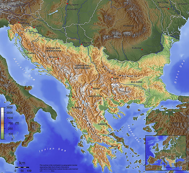
English: The topography of the Balkan Peninsula, as defined by the Danube-Sava-Kupa line. |
||||||||||
| 期 | 2006, before Serbia and Montenegro was split into two separate states. | ||||||||||
| 碼 | 己作 | ||||||||||
| 作者 | Captain Blood~commonswiki | ||||||||||
| 准 (重用此檔案) |
|
||||||||||
| 其他版本 |
|

檔誌
揀日尋檔。
| 日時 | 縮 | 度 | 用戶 | 註 | |
|---|---|---|---|---|---|
| 今 | 二〇一五年一一月一四日 (六) 〇九時一五分 | | 八四〇矩七六七(六三八 KB) | SilentResident | Corrected mistake in which the Aegean and Ionian islands were marked as part of the Balkan topography. |
| 二〇一二年二月一日 (三) 二一時五三分 |  | 一三八四矩一二六四(七二六 KB) | Ras67 | losslessly cropped with Jpegcrop | |
| 二〇一二年二月一日 (三) 二一時五二分 |  | 一三八四矩一二六四(七二六 KB) | Ras67 | losslessly cropped with Jpegcrop | |
| 二〇〇六年四月一四日 (五) 一七時三四分 |  | 一四〇〇矩一二七八(七四八 KB) | Captain Blood~commonswiki | labels | |
| 二〇〇六年四月二日 (日) 一七時二二分 |  | 一四〇〇矩一二七八(七四八 KB) | Captain Blood~commonswiki | Una border | |
| 二〇〇六年四月一日 (六) 一九時三八分 |  | 一四〇〇矩一二七八(七四一 KB) | Captain Blood~commonswiki | {{Bild-GFDL-GMT}} |
檔所繫者
下頁連本檔:
總文之用
下他共筆連本檔:
- af.wikipedia.org上之用
- ang.wikipedia.org上之用
- an.wikipedia.org上之用
- ar.wikipedia.org上之用
- arz.wikipedia.org上之用
- ast.wikipedia.org上之用
- be-tarask.wikipedia.org上之用
- bg.wikipedia.org上之用
- bn.wikipedia.org上之用
- bs.wikipedia.org上之用
- ca.wikipedia.org上之用
- ckb.wikipedia.org上之用
檢視此檔案的更多全域使用狀況。